Return to Home Page

Return to Tour Introduction.

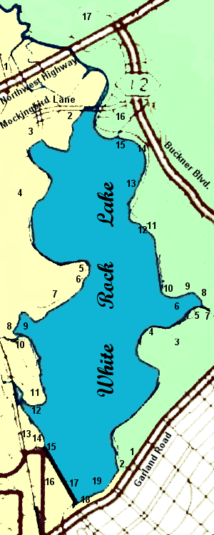
Tour Index Map
On this map, East is to the top. You may click on each point of interest to go to the corresponding tour page. Please note: All locations shown on map are approximate.

US Government Aerial Photo Map of White Rock Lake

WEST SHORE

  1. DART's White Rock Station
  2. Mockingbird Point Off-Leash Dog Park
  3. West Lawther Drive Entrance Portal
  4. Cox Cemetery
  5. Miji Point
  6. Free Advice Guys
  7. Mount Vernon
  8. WPA Bridge
  9. Lily Pad Bay
  10. Tangled Trees
  11. Tee Pee Hill
  12. Old Municipal Boathouse
  13. Jacob Buhrer Dairy farmhouse site
  14. Old Water Filtration Plant
  15. Old Water Pump Station
  16. Old Fish Hatchery Nature Area
  17. Dam and Spillway
  18. Republic of Texas Highway Marker
  19. Garland Road Fishing Pier

Map of White Rock Lake Park

EAST SHORE

  1. Rancho Encinal (DeGolyer Estate)/Dallas Arboreturm
  2. East Lawther Drive Entrance Portal
  3. Camp White Rock Site
    (CCC, U.S. Army Air Corps, and German P.O.W. camp)
  4. Winfrey Point
  5. Sunset Bay
  6. Dixon Branch
  7. WPA Bridge
  8. Park Board Bridge
  9. Stone Tables Picnic Area
  10. Dreyfuss Club/Sol Dreyfuss Memorial Point
  11. Bath House Cultural Center
  12. Water Theater and Bath House Lawn
  13. Corinthian Club
  14. Big Thicket
  15. White Rock Sailing Club
  16. Boy Scout Hill
  17. Flag Pole Hill

Adapted from a Texas Department of Transportation map.

This website opyright © 1996-2011 by Steven Butler, Ph.D. All rights reserved.